Posts

Showing posts with the label fossil
Image
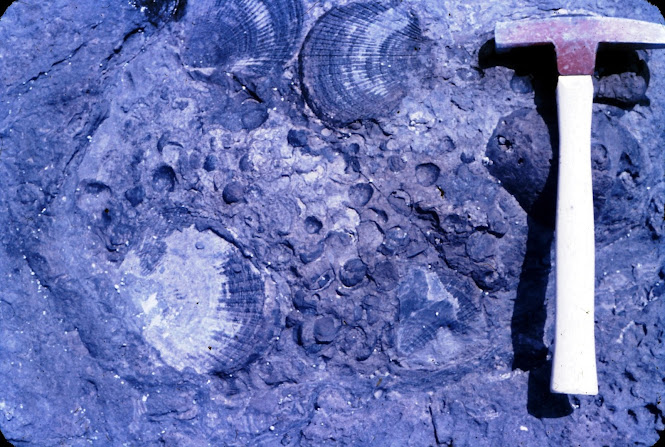
  FIELD GEOLOGY OF THE SHOALHAVEN DISTRICT (PART 21) Chapter 13. The Termeil and Durras Districts   Until tourism brought the present growth of holiday resorts, this part of the coast remained relatively unknown. Much of it is still unspoiled and every effort should be made to keep it that way. This is especially true of the coastline between Pebbly Beach and Pretty Beach, where the slopes of the Murramarang Range fall steeply to the sea and tiny islets lie inshore. The whole of the country from Bawley Point south to Bateman’s Bay is thickly covered by spotted gum forest and has been reserved as a State Forest. The only use of the land for farming has been near Termeil, Murramarang and Durras Mountain; the rest is virgin bush.  The Conjola Formation dominates the geology and considerable progress has been made recently towards the unravelling of its stratigraphy. There is a greater thickness of sedimentary rock here than has been measured over most of the area north of Ul...
Image
  FIELD GEOLOGY OF THE SHOALHAVEN DISTRICT (PART 20) CHAPTER 12.  The Milton-Ulladulla District   The Milton intrusion dominates the geology of this part of the country. Its rich soils lie conveniently close to Ulladulla Harbour and settlers began to arrive here about 1830. However, apart from the country underlain by the Milton Monzonite, the rest of the landscape has changed little since Cook first viewed it in 1770.  Apart from the igneous rocks near Milton, The Conjola Formation is dominant in this area. In recent years there has been a revision in the nomenclature of the Formation and it is now known to consist of sediments of widely varying ages, all within the lower Permian. Contrary to earlier ideas, the lower beds are equivalent to the lower part of the Dalwood Group in the Hunter Valley. Some parts of what has been called the Conjola Formation are as young as the lower Maitland Group. Research into this aspect of Shoalhaven district Geology is still in prog...
Image
  FIELD GEOLOGY OF THE SHOALHAVEN DISTRICT (PART 17) Chapter 9 continued   Year 7 class Moss Vale High School  at  Bungonia Caves November 1973 Excursion 9c Bungonia, South Marulan and Tallong These are just a few of the places of interest across the river, which are worth a visit as part of excursions to the Goulburn district. Bungonia Caves An extensive area of Silurian limestone crops out from South Marulan over a distance of 7 miles in a south westerly direction. The caves are reached by travelling east from Bungonia village. Part of the area is in a reserve and was formerly maintained for tourists until visitor numbers dropped as people preferred to visit the more spectacular caves elsewhere in NSW. The  Lookdown  is the best known feature here. There is a very The Lookdown December 1963 sharp drop of 1,200 feet to Bungonia Creek. This may be descended with care to the right of the lookout. The limestone here contains typical Silurian fossils, par...
Image
  FIELD GEOLOGY OF THE SHOALHAVEN DISTRICT (PART 11) Chapter 6  The Yalwal and Burrier Districts   Scattered throughout Australia are numerous ghost towns. Yalwal is such a place, but time has removed all but a trace of the town itself and left only the mines which once brought prosperity.  That famous cleric-cum-geologist, the Rev. WB Clarke, noted the existence of gold here as early as 1852. He reported that fine gold was to be found in Danjera and Yalwal Creeks, recommending further prospecting to the local settlers. The ‘golden era’ began in 1872 and lasted into the present century, with minor revivals ever since.  The Permian strata rise gradually to the west, exposing the basement rocks in all valleys west of Grassy Gully. The oldest strata are comparable to those known to be of Ordovician age and consist of altered clastic sediments. These are exposed only in parts of Danjera and Yarramunmun Creeks. They are overlain by sandstones and conglomerate, contai...