Posts

Showing posts with the label district
Image
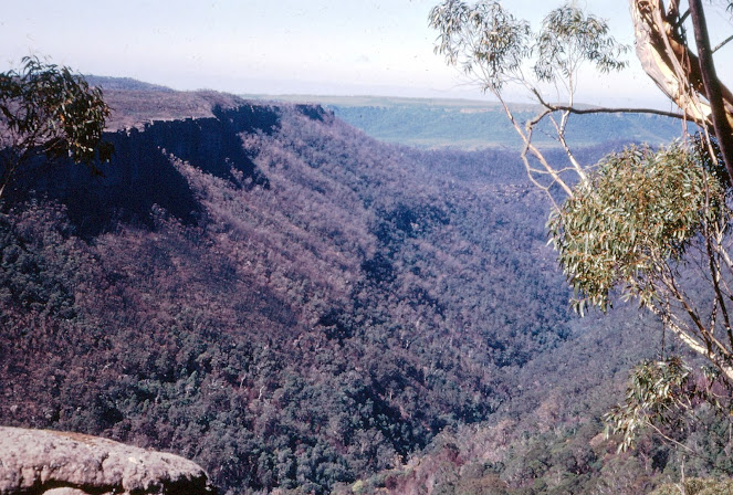
FIELD GEOLOGY OF THE SHOALHAVEN DISTRICT (PART 23) CHAPTER 15: THE CLYDE RIVER VALLEY T aking its rise at an elevation of 2,500 feet near Sassafras, this small river flow south and descends by way of a great canyon to a level of 200 feet at Yadboro. It does this in less than 20 miles, yet it is a further 40 miles to the sea downstream. This is a peculiar result of the dip of the Shoalhaven group sediments. At one time, these must have extended further south than at present. When the area was uplifted, it was tilted to the north, so that the ancestral Clyde River had to erode its bed against this trend.  This undoubtedly led to the formation of many waterfalls and the evolution of the canyon upstream from Yadboro.  The southern edge of the sandstone scarp presents a bold face and is broken into numerous outliers. Some such as The Castle and the Pigeon House are well known to bushwalkers, but there are many others. They all have a similar structure, being capped by cliffs of the...
Image
  FIELD GEOLOGY OF THE SHOALHAVEN DISTRICT (PART 22) CHAPTER 14. The Nerriga District The Permian sediments reach their highest level east of Nerriga and it is in this area that spectacular examples of erosion are most common.  Extensive denudation has exposed the underlying basement rocks over a wide area. These are a continuation of the rocks exposed at Yalwal and Ettrema in the north.  The  Budawang Range  reaches a height of 3,711 feet at Currockbilly Mountain and a similar height at Mount Budawang a little further south. This prominent ridge is the backbone of the basement, consisting essentially of a narrow belt of resistant Devonian strata flanked by Ordovician slates. Marine fossils occur in both these groups as well as sporadic mineralisation. Alluvial gold has been extensively mined, but reefs have rarely proved profitable.  The core of the area described in these pages is a wild confusion of deep valleys and remarkable sandstone peaks. It is a pl...
Image
  FIELD GEOLOGY OF THE SHOALHAVEN DISTRICT (PART 15) Ettrema and Beyond – the Great Gorges. Excursion 9a One must never underestimate the erosive power of running water. Almost as fast as the uplifting process begins, many streams large and small begin to level the land again. Nowhere is this better seen than in the gorge country west of Nowra, where scrubby sandstone plateaux give way to great canyons, and tinkling waterfalls demonstrate the ceaseless battle between the two. Ettrema Gorge January 1969 From sea level at Nowra, the sandstone surface rises, almost imperceptibly, to a height of 2,500 feet in the west. The Shoalhaven River and its tributaries have removed this resistant layer along their courses and exposed the older rocks below. Unlike Kangaroo Valley, these gorges have little to attract the settler since their few level areas are comparatively infertile and access is difficult indeed. It has taken the discovery of minerals – gold, silver, and lead – to cause man to d...
Image
  FIELD GEOLOGY OF THE SHOALHAVEN DISTRICT (PART 14) Chapter 8. The Tomerong District   In earlier days, when there were few casual visitors to the South Coast,  Tomerong  was much more a rural centre than it is today. The growth of holiday areas around Jervis Bay and St George’s Basin has rendered it less important.  Tomerong is situated where the southern road first passes through the Nowra Sandstone onto the widespread Wandrawandian Siltstone. The change is marked by a noticeable improvement in the soil, and this in turn has led to the growth of spotted gums and turpentine, in contrast to the poorer types growing on sandstone soils. The sawmills around Tomerong and Wandandian capitalise on this forest wealth and provide local employment.  North and west of Tomerong are outcrops of the overlying sandstone and the Berry Formation. Elsewhere, the Wandrawandian Siltstone is the dominant rock type, except along the shores of Jervis Bay, where a dome structure...
Image
  FIELD GEOLOGY OF THE SHOALHAVEN DISTRICT (PART 13) Chapter 7: The Beecroft Peninsula The heads of  Jervis Bay  are unique features. Both of them project seawards contrary to the south westerly trend of the coast and both are flanked by great sea cliffs unequalled in NSW. The northern headland is much more accessible than the southern. The southern headland lies in Commonwealth Territory and will be considered in chapter 8.  The geological map indicates that the Conjola Formation is the dominant underlying rock, but there is far more to the understanding of its origin than this fact alone. It would appear that a combination of folding and a major offshore fault may have elevated this area in comparatively recent times. If we remember that the sea has been at its present level for only the last 10,000 years, then we cannot explain the cliffs or the great opening of Jervis Bay by marine erosion only. Suggested explanations for these features include the idea that the ...