Posts

Showing posts with the label slate
Image
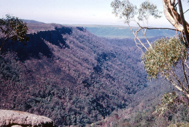
  FIELD GEOLOGY OF THE SHOALHAVEN DISTRICT (PART 22) CHAPTER 14. The Nerriga District The Permian sediments reach their highest level east of Nerriga and it is in this area that spectacular examples of erosion are most common.  Extensive denudation has exposed the underlying basement rocks over a wide area. These are a continuation of the rocks exposed at Yalwal and Ettrema in the north.  The  Budawang Range  reaches a height of 3,711 feet at Currockbilly Mountain and a similar height at Mount Budawang a little further south. This prominent ridge is the backbone of the basement, consisting essentially of a narrow belt of resistant Devonian strata flanked by Ordovician slates. Marine fossils occur in both these groups as well as sporadic mineralisation. Alluvial gold has been extensively mined, but reefs have rarely proved profitable.  The core of the area described in these pages is a wild confusion of deep valleys and remarkable sandstone peaks. It is a pl...
Image
  FIELD GEOLOGY OF THE SHOALHAVEN DISTRICT (PART 12) CHAPTER 6 (CONTINUED) Excursion 6c   Yalwal  (40 miles return)  This excursion covers the most interesting area of basement rocks in the Shoalhaven district. It has the added interest of being mineralised and of having been the source of $500,000 worth of gold. The new dam on Danjera Creek is included in this excursion.   Proceed as in Excursions 6a and 6b. Take the Yalwal road 0.3 miles past Saltwater Creek. The road climbs steadily, reaching the base of the Nowra Sandstone 400 feet above sea level, or approximately the same height as The Pulpit. This illustrates the gradual dip of the strata to the east. Stop where gravel has been obtained on the right, 1.7 miles from the Burrier road.  Stop 1. The Nowra Sandstone cliff is a short distance away to the right, from where there is a sharp drop of 600 feet to Barringella Creek, a small tributary of the Shoalhaven.  The road gradually rises and in ...