FIELD GEOLOGY OF THE SHOALHAVEN DISTRICT (PART 20)
CHAPTER 12. The Milton-Ulladulla District
The Milton intrusion dominates the geology of this part of the country. Its rich soils lie conveniently close to Ulladulla Harbour and settlers began to arrive here about 1830. However, apart from the country underlain by the Milton Monzonite, the rest of the landscape has changed little since Cook first viewed it in 1770.
Apart from the igneous rocks near Milton, The Conjola Formation is dominant in this area. In recent years there has been a revision in the nomenclature of the Formation and it is now known to consist of sediments of widely varying ages, all within the lower Permian. Contrary to earlier ideas, the lower beds are equivalent to the lower part of the Dalwood Group in the Hunter Valley. Some parts of what has been called the Conjola Formation are as young as the lower Maitland Group. Research into this aspect of Shoalhaven district Geology is still in progress.
Excursion 12a
Milton-Ulladulla (17 miles)
Included in this excursion are splendid exposures of the Milton intrusion, richly fossiliferous Permian sediments, and Tertiary Volcanics in the form of dykes and flow remnants.
Route: Yatteyatah-Little Forest-Milton-Ulladulla-Mollymook-Bannister’s Point-Narrawallee-Milton
The excursion commences at the junction of the Prince’s Highway and the Porter’s Creek Dam road. The road south skirts the edge of a northerly part of the Milton intrusion. A diversion may be made to Lake Conjola entrance, by turning left 1 mile south. Silica has been quarried in that area.
Through Yatteyatah, the road descends to the lush pastures of the Milton district. At first the road crosses alluvial soils, but shortly after reaches outcrops of monzonite. Stop where the rock is exposed in a deep cutting.
Stop 1. The rock here is rather weathered and better specimens may be obtained on nearby hillsides. The entire Milton intrusion varies greatly, in places (as here) resembling dolerite while elsewhere it grades into more typical monzonite or even trachyte.
Turn right along Little Forest Road, half a mile further south. The road soon leaves the intrusion and continues towards the Little Forest Plateau through poorer country. Three miles from the highway, turn right. The road then descends to Little Forest Creek.
Stop 2. Another small exposure of Ordovician slate is exposed here. The unconformity may be examined by walking up the road on either side of the creek until slate is replaced by sandstone. Upstream, a small inlier of the Coal Measures may be found by following the creek for half a mile. Beyond Little Forest Creek, the road rises sharply onto that part of the intrusion seen from the Rotary Lookout (see Excursion 11a, Stop 7).
Return to the highway. One mile further south the road climbs sharply through monzonite. Stop where a small quarry is seen on the left towards the top of the hill.
Stop 3. The rock here is fairly typical of the intrusion, being a variety of porphyritic monzonite. The large felspar phenocrysts are noteworthy. The rock face also displays a number of aplitic and pegmatitic veins.
The view to the west shows the level Nowra Sandstone horizon behind Little Forest, with the Tianjara mesas further north. Mt Kingiman blocks the view towards Pigeon House in the south west.
Continue through Milton towards Ulladulla. The Nelligen road (Excursion 12b) is marked by a sign pointing to the blue metal quarries.
Stop at a point 2.2 miles further south, just before Mollymook.
Stop 4. Olivine basalt, part of a flow remnant, occurs here in the road cutting. It is very weathered and good examples of spheroidal weathering may be seen. Building excavations nearby in Mollymook have revealed large masses of resinous opalised wood beneath the basalt. These appear to have been logs buried beneath the flow and thus preserved. Any new excavations in this locality are worth checking for further occurrences.
Continue towards Ulladulla. Stop along the waterfront where a large tourist map has been erected.
Stop 5. Ulladulla Harbour may have been formed by the erosion of a number of east-west dykes, traces of which have been found at the northern end of the beach. It has become a haven for fishing craft and is the safest anchorage between Jervis Bay and Bateman’s Bay.
Warden’s Head lighthouse may be reached by passing through the camping area or by following Deering Street, which turns left at the top of the hill through Ulladulla. The lighthouse is approximately one mile east of the highway.
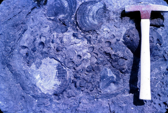
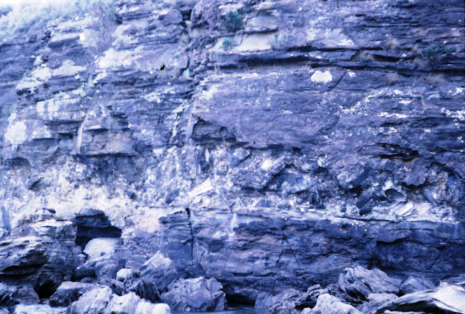
Stop 6. Warden’s Head is a well-known collecting ground for Permian fossils and a whole day could be spent here. A track descends to the rock platform a little south of the lighthouse. From the cliff top, observe the prominent north-south strike of the strata below, which has led to the formation of bomboras just off the platform. The sediments, mainly siltstone, dip towards the west at this point, but there is a considerable local variation in this.
 |
| Fossils at Warden Head November 1963 |
At the point where the track reaches the rock platform, the beds are much disturbed. A small clastic dyke may be seen a few feet to the west and there is abundant evidence of slumping within the siltstone. Fossils may be found in the rocks to the south but more especially to the north. If time permits, walk right around to Ulladulla harbour. Spherical concretions (cannonballs) occur here and there are several glendonite beds, resembling those at Huskisson and Crookhaven. The sediments are richly fossiliferous and the superabundance of fossils has made some of the beds into impure limestone. Some of this proves to be largely made of the spines of small brachiopods, such as Stropholosia and Terrakea.
Return to Ulladulla. The return trip to Milton may be made by way of Mollymook, Bannister’s Point and Narrawallee. At Bannister’s Point, silica has been quarried extensively. A large dyke occurs near the ruined jetty on the northern side of the headland, and this seems to be the origin of the quartz solutions which formed the quartzite. The sandstone at Bannister’s Point has a prominent easterly dip, which can be clearly seen from the road.
Excursion 12b
Milton and Burrill Lake(20 miles)
This excursion includes features similar to those covered in the previous one, with the addition of several large dykes and scenic mountain areas.
Route: Nelligen road from Milton, thence via the Wheelbarrow Road to the Prince’s Highway at Lake Burrill and return to Milton.
From Milton, the Nelligen road goes south across the monzonite for 4 miles. Good views of the Little Forest Plateau, The Castle, Mt Kingiman, and the top of the Pigeon House are to be had near Milton. Stop at the blue metal quarries, 5 miles from Milton. Request permission to enter.
Stop 1. The quarry being worked to the right of the road exposes a pale porphyritic monzonite, rather different to that seen at Milton. There are few veins or cavities and the jointing is irregular. The older quarry, on the left a little further south, shows considerable variation in the rock fabric. Much of it has been serpentinised, evidently by solutions rising from below. Most of the rock is finer grained than that seen in the other quarry, apparently because it is nearer the edge of the intrusion. Labradorite phenocrysts, however, are still plentiful.
Just past the quarries, a view of Burrill Lake reveals a small delta at its northern end. Lakes Conjola and Burrill are both examples of drowned valleys. A little further on, the road passes onto the Conjola Formation and outcrops of sandstone may be seen in road cuttings and in a quarry beside the road. Three miles past the monzonite quarries, the road to Mt Kingiman branches to the right.
Diversion 1. Some 1.6 mile along this road, there is a further branch. The left branch leads to Jindelara Creek and the right to Mt Kingiman. Keep to the right branch. The road climbs steadily. Outcrops of the Wandrawandian Siltstone may be seen after 1 ½ miles and loose blocks of Nowra Sandstone beyond this. The road skirts the western edge of the mountain for a further 1 ½ miles before becoming impassable. At any suitable point, the sandstone ridge above may be climbed, from which superb views of Milton, the Pigeon House, and the Little Forest Plateau may be obtained.
Return to the other branch and turn right. Stop at an old bridge 1 mile further on.
This area was burned out by severe bush fires in 1968 and the bridge was badly damaged. Immediately below the bridge is a fine waterfall, flowing over sandstone of the Conjola Formation. The track ahead may be followed to the Pigeon House. Take the left fork near Jindelara Creek 1 ½ miles ahead. The distance from the fall to the summit is about 5 ½ miles. Return to the Nelligen road and continue in a southerly direction. Turn right 1.3 miles further on.
Diversion 2. This road leads to a group of small farms situated on part of the Termeil Essexite intrusion (see Excursion 13a). This area drains into Boyne Creek which probably carries alluvial gold similar to that found on Murramarang Beach.
Views of the Pigeon House are frequent along this road. Turn left just past a bridge after 1.3 miles. Shortly after, cleared country is reached and essexite boulders are plentiful. Return to the Nelligen road. Turn right along the Wheelbarrow Road, which descends to the Prince’s Highway near Burrill Lake. Turn left along the highway and right to Dolphin Point just before the bridge over the lake. This leads out to the coast south of Burrill Entrance.
The coast from Burrill Entrance south to Lagoon Point has many features of interest.
The rocks are principally siltstone and sandstone of the Conjola Formation, and closely resemble the outcrops at Warden’s Head, 4 miles to the north. They contain numerous fossils and exceptionally large erratics composed of all kinds of metamorphic rocks.
Two large porphyritic dolerite dykes strike east-west across the rock platform about 500 yards south of the entrance. Both have arched up the intruded rocks in a similar fashion to the Berrara dyke. The northern dyke has a width of 45 feet and the southern 120 feet, making it one of the largest recorded dykes on the south coast. There is a very marked bleached zone on both sides of these dykes, where the igneous rock has been altered by solutions derived from the sedimentary rocks.
 |
| Schist erratic January 1966 |
Further south, a number of erratics project prominently from the surface of the platform. Some of these are composed of highly contorted quartzite, others of granite and of intermediate volcanic rocks. They are known to bear some resemblance to the rock types still outcropping south west of the Sydney basin towards Canberra and they may have been brought from that direction.
Glendonites and concretions occur in the siltstone south towards Lagoon Point (1 mile from the large dyke). Good examples of marine fossils are abundant along the shore and some fine examples of crinoids have been found in this area.
Questions
1. Is there any evidence to support the suggestion that the Milton intrusion is older than the Shoalhaven Group? Give support for the contrary view.
2. Give an account of the origin of the sedimentary structures seen at Warden’s Head.
3. Construct a geological history of the Milton-Ulladulla district.
4. Discuss the petrology of the Milton intrusion, using data gained from the outcrops studied on these excursions.
5. The base of the Nowra Sandstone stands at 1,500 feet near Little Forest, 2,100 feet at the Pigeon House but only 1,200 feet at Mt Kingiman. Suggest reasons for this situation.
https://johnsbluemountainsblog.blogspot.com/2013/12/links-to-all-blog-entries-and-relevant.html All Blue Mountains blogs and videos
All New England and other Geology blogs and videos
Limestone Caves of NSW
Song Studies. Bible studies based on hymns and songs
Shoalhaven District Geology.


Comments
Post a Comment